
Mapping Israeli Apartheid in the West Bank
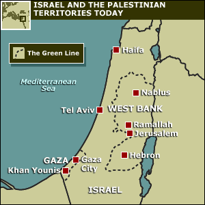 The Occupied Palestinian Territories (OPT) comprises two areas, the Gaza Strip on the west coast, and the West Bank, further to the east, which, with East Jerusalem, should form the basis for a Palestinian state.
It is worth noting that while Israel “withdrew” from the Gaza Strip to much propagated fanfare, it still exercises a tight stranglehold over the population and never really left this, the most densely populated area in the world.
 Israeli encroachments have not simply meant that the Gaza Strip and the West Bank are territorially discontiguous, illegal Israeli settlements (that are Jews only) are further eating into the Palestinian West Bank, rendering it into “Swiss-cheese” bantustans for the Palestinians.
This is an important reason why one state advocates call for a democratic state for all its citizens, arguing that the two state solution is no longer feasible.
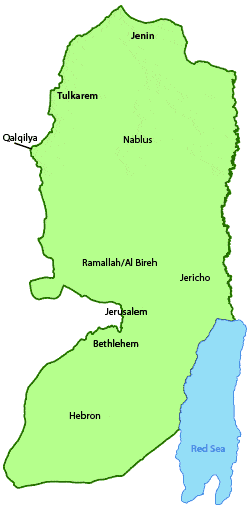
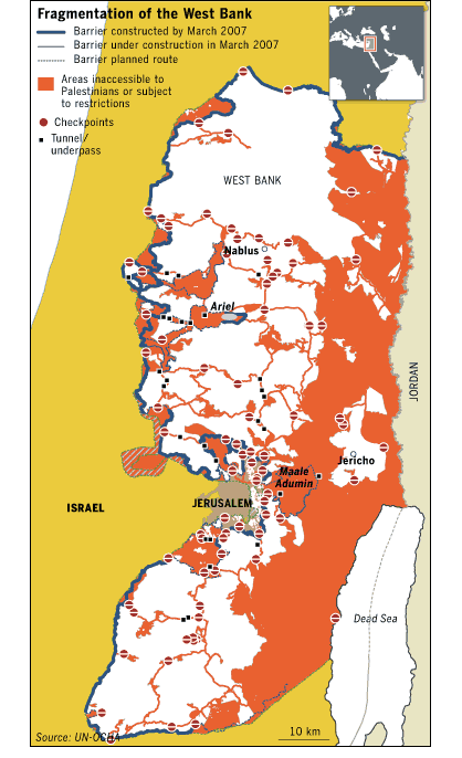
Two maps follow which show these carved out pockets in the West Bank in more detail.
1. Mapping Israeli Apartheid in the West Bank
Vermonters for a Just Peace in Palestine/Israel have created the animated map shown below based on information from OCHA (United Nations Office for the Coordination of Humanitarian Affairs — they’ve included several report links on their site); caught this at Haitham’s place.
| The Palestinian West Bank, bordered by the 1949 Green Line. | |||
| Israeli settlements and settlement blocks established since 1967 in violation of international law and UN Security Council Resolutions. | |||
| Completed and planned sections of Israel’s “security fence” – the Wall. | |||
| Sections of the Wall under construction. | |||
| Palestinian areas completely surrounded by the Wall and/or additional barriers. | |||
| Palestinian areas trapped between the Wall and the Green Line. | |||
| Boundaries of Palestinian “enclaves” established by Israel. Travel between “enclaves” controlled by Israeli army. | |||
| Trisection boundaries established by Israel. Permits required to travel between sections. | |||
| Jordan Valley now virtually off-limits to Palestinians. |
2. And a UN map featured recently in the Financial Times, linked to in Press Picks a few days ago but is worth reproducing here:
From the article:
“… 2.5m Palestinians are confined to dozens of enclaves separated by Israeli roads, settlements, fences and military zones.
Produced by the United Nations’s Office for the Co-ordination of Humanitarian Affairs, it is based on extensive monitoring in the field combined with analysis of satellite imagery. It provides an overall picture officials say is even more comprehensive than charts drawn up by the Israeli military.
The impact of Israeli civilian and military infrastructure is to render 40 per cent of the territory, which is roughly the size of the US state of Delaware or the English county of Norfolk, off-limits to Palestinians.
The rest of the territory, including main centres such as Nablus and Jericho, is split into isolated spots. Movement between them is restricted by 450 roadblocks and 70 manned checkpoints.
The UN mapmakers focused on land set aside for Jewish settlements, roads reserved for settler access, the West Bank separation barrier, closed military areas and nature reserves.
What remains is an area of habitation remarkably close to territory set aside for the Palestinian population in Israeli security proposals dating back to postwar 1967.
The process of enclosing the civilian enclaves has accelerated in the years since the outbreak of the Palestinian uprising in 2000, and the reintroduction by Israel of its military rule even in areas previously under Palestinian Authority security control.”
Recent Comments