
Google Earth Canada: This iPod user rocks
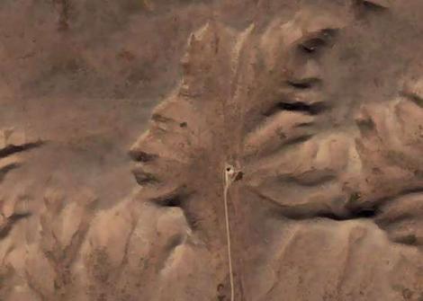
The rock formation in Canada which looks like an Indian listening to an iPod.
Photo: Google Earth
Related coverage
- YouTube video: iPod listener rocks
Stephen Hutcheon | SMH
October 25, 2006 – 12:40PM
Google Earth spotters have discovered a strange rock formation in the prairies of central Canada that resembles a native American in headdress listening to an iPod.
The rock formation is in Alberta, Canada about 300km southeast of the provincial capital of Calgary, near the border with Saskatchewan.
Dubbed the Alberta Indian, the formation was discovered by a Google Earth spotter nicknamed Supergranny.
The area is situated in one of Canada’s key gas fields. The nearest urban centre is Medicine Hat, a town of 56,000 known as “The Gas City” which claims to be Canada’s sunniest spot.
The rock formation’s “face” measures about 255m across and its about 225m long.
The feature which resembles an iPod earphone is actually a road leading up to what one Google Earth spotter who is knowledgeable about the region says is a natural gas wellhead.
In the Google Earth forum, the person names the well as Piper Medhat 6-20-12-1.
Another Google Earth spotter who appears to have some knowledge of geology write that the figure “seems to consist of an area naturally eroded out of the south side of a flat-topped mesa”.
(According to the Macquarie Dictionary, a mesa is a land form having a relatively flat top and bounded wholly or in part with steep rock walls, common in arid and semi-arid parts of the world.)
“I can see no sign of it having been created by modern or ancient people. In generally, the shapes making up the Alberta Indian conform to the sort of cursive, fractal erosion features found all around that part of Alberta,” the spotter called LoRezFlyer writes on the Google Earth forum.
Google Earth – a program which combines satellite and aerial photography – offers armchair explorers a new frontier of discovery.
Other interesting Google Earth finds include what looks to be hovering cars in Perth, a strange man-made formation in central China that is used for military training purposes and and topless sunbathers in the Netherlands.
The feautre can also be found here on Google Maps. The Google Earth coordinates are 50° 0’38.20″N 110° 6’48.32″W. To operate Google Earth you need to download a free program.
Recent Comments